
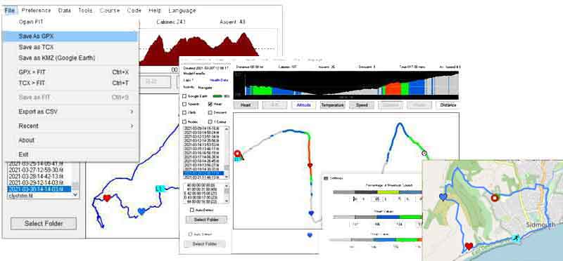
FIT ConVerter 4.6 converting FIT files for free on your PC
Convert FIT files to GPX , TCX , CSV & KML
No online processing ! Your data always remains private & secure!
How to save FIT as GPX
- Go File , Open FIT
- Use Openstreetmap option to check it out.
- Save as GPX
 |
| You may have to » refresh this page to see latest version. |
 |
||
| Secure Download with NO JUNK added! | ||
| Fit-ConVerter 4.60 Setup for Windows | ||
| Always run setup as Administrator | ||
| W7/10 click here | ||
| Includes examples of FIT files | ||
| FIT-ConVerter 4 PDF Quick Guide | ||
 |
|
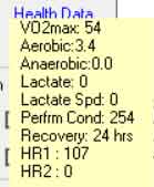
| Battery levels | VO2max, Aerobic ,Anaerobic values etc |
|
Convert GPX / TCX to FIT
- Go File , GPX > FIT
- Use Openstreetmap option to check it out.
- Select a gpx file
- A FIT file is created automatically on your PC
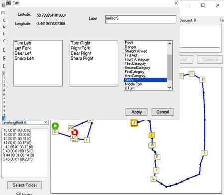
Add Turn by Turn directions
|
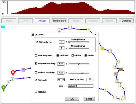 |
Editing and Adding Course Points
|
 |
Fit file structure for Dummies
Want to know more aboutconverting FIT files to GPX ?
Check out : Fit File Structure for Dummies
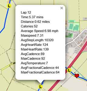
Show Lap Data
|
 |
How to Add or Edit a Language File
|
How do I add Turn By Turn (TBT) directions to a FIT file?
- Load FIT file & Double click on a node and add TBT direction.
- Save as FIT .
- Course FIT files do not contain temperature ,heart, cadence, speed data.
As a precaution, you cannot replace the original file.
How to easily and accurately create a FIT Course using Basecamp.
Only direct routing will create a gpx which contains multiple waypoints needed to create a FIT Course.
This is tedious and laborious. However, there is a trick:
- Create a route in Basecamp NOT using direct routing but select , say , cycling or hiking.
- Select Route and Right Click , then Right Click & tick 'Create Track from Route'.
- Save as GPX
- Load GPX into GPX ConVerter and from the main menu click GPX to FIT.
- There is one drawback: Waypoint labels are all the same.
Removing All Course Points
Go Course, Remove All Course Points
Remove selected Course Points
Right Click on a Course point and select Remove
FIT ConVerter 4 - Analysing Hidden Data
|
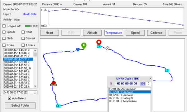
|
| Speed & Distance compressed |
 |
TYPWiz 7
Change the appearance of your Garmin map! Change All the Colours! Change the colours and bitmaps of Areas Change the bitmaps of your Points Check out TYPWiz 7 |
 |