
DEM Look on Custom Garmin Maps ( now irrelevant & obsolete )
'DEM LOOK CREATOR' turns elevation data into overlapping polygons which can be added to your Garmin maps.
At the same time it generates a TYP file specifically designed to colour your elevation data.
|
Yes, it is possible to convert readily available DEM data yourself and add it to your IMGs using the 'Polygon' method with some pleasing results. |
|
1) You need to download the SRTM (Shuttle Radar Topography Mission) DEM data.
This generally comes in blocks.
2) Convert data to contours 3) Turn contours into polygons and generate a TYP file
|
 |
| How to Download SRTM DEM data | ||
 |
|
With DEM LOOK CREATOR you can download all .hgt files. Just enter / paste coordinates from an Openstreet Map url and click the download button. |
| How to convert .hgt data to contours | ||
 |
 |
 |
 |
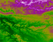
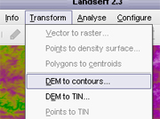
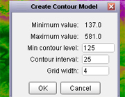
We are using Landserf . It is difficult to get from the Landserf site itself but search around ; it's a JAVA program. Load the .hgt file and convert to contour vectors Set the interval to say 25m and set minimum contour level to a multiple of your interval ( ie 25) In the case above the minimum value was 137.0 .Our minimum contour level is either 125 or 150. Experiment. The smaller the interval the greater the number of polygons it will create . The more levels the more polygons in your TYP file - The TYP file used above contained 16 different polygons , created automatically in DEM LOOK CREATOR. Save as geo vector txt. |
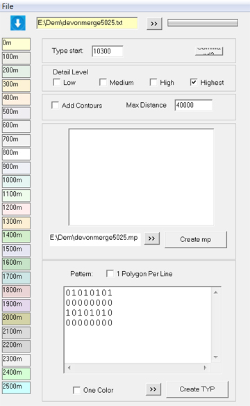
Use DEM LOOK CREATOR to create .mp polygons and TYP file. DEM LOOK CREATOR turns contours into an .mp file ,adds the correct type number and label to each polygon and creates a suitable TYP file. |
 |
|
1) Load elevation txt file 2) Enter type number to start polygon range 3) Set view levels (from low to highest) 4) Click Create Map |
||
1) Define or load Pattern 2) Tweak Colours 3) Click Create TYP |
||
4) Use mapuploader4 to generate gmapsup or add to Basecamp. |
Download DEM LOOK CREATOR BETA
Key : 25477264