
How to create line draworders in Basecamp
|
Forget about line draworders on your gps There is no logic to the algorithm - ie bridges over dual carriageways or motorways often only overlap one of the highways . However, it is possible to force line draworders in Basecamp. |
 |
| bitmap footbridge ALWAYS on top |
One way to get 'overlapping' bridges is by placing them all in one img and make the priority of this map higher than the rst of the maps - in my experience, this is not guaranteed to work.
The following applies to Basecamp and more than likely will not apply to your gps device.
Bridges
 |
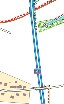 |
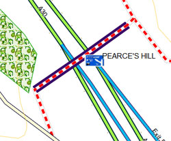
| Garmin TOPO No bridges across Motorways | Bridges Over Motorways |
- Routable types have a higher draworder then non routable ones
- Changing a non routable line from a bitmap to a non bitmap gives it a higher draworder
- Change rivers, streams etc to bitmap lines - In TYPWiz.click 'Convert to Bitmap' .
- Some extended type numbers also have a default higher draworder , ie 108
The following procedure is just one way of creating bridges Problem: You can't use 0x1 for a Motorway as nothing crosses 0x1 ! Solution 1 Bridge No Outline: |
|
| Use 0x1 - 0x7 as bridges | highway=motorway & bridge=* [0x1 road_class=4 road_speed=7 resolution 24 continue] |
use 0x12 for mways and make this line TRANSPARENT |
highway=motorway [ 0x12 road_class=4 road_speed=7 resolution 16 continue] |
| use an extended line number to show the motorway AS A BITMAP | highway=motorway [ 0x10108 resolution 16 ] |
Solution 2 Bridge With Outline: |
|
| Use 0x108 as a a transparent bridge outline | bridge=* [0x1 resolution 24 continue] |
| Use 0x1 - 0x7 as bridges | highway=motorway & bridge=* [0x2 road_class=4 road_speed=7 resolution 24 continue] |
use 0x12 for mways and make this line TRANSPARENT |
highway=motorway [ 0x12 road_class=4 road_speed=7 resolution 16 continue] |
| use an extended line to show the motorway AS A BITMAP | highway=motorway [ 0x10108 resolution 16 ] |
Using this method you can have railway lines / even canals ALWAYS crossing motorways and other highways.For railway lines perhaps use type 0x0 (no bitmap)
The draw back is :
- you will need to reorganise you highway numbers
- You are having to create extra lines