
Garmin's Active Routing
Maps highlight various popular routes depending on your activity, ie cycling or hiking
What is Garmin's Active Routing?
 |
- Maps with Active Routing contain a number of 'popular' routes created for hiking , cycling and mountain biking.
- Highways have been checked for access ensuring cyclists don't get routed via footpaths
- When you select an activity,ie cycling, all cycle routes are highlighted, same for walking, hiking etc
- Unfortunately, they are still difficult to see unless you use TYPWiz7 to edit their colour,size or pattern
- Details of all routes are contained in a .db file located in the SQL folder when using a gps device.
|
 |
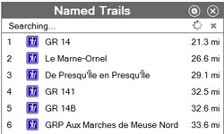
- Basecamp will add a new search option 'Named Trails' if it has found the db file.on your device matching the map id or if the appropriate flags have been set if the TOPO is located on a PC.
- Note : placing a sql folder in the directory containing the IMGs will not kick in this option!
- A 9 byte data block found in the main img header ,ofset &30 , generates a 12 character header using a complex but understood algorithm.This must match the .db title!
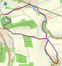
- Clicking on a 'Named Trail' will outline the route - as seen on left.
- Lines with active routing use the same routing types as 'normal' lines,ie 0x1,0x2 etc
- TOPO France V3 pdf contains more info
|
| |
|
 |
 |
| |
Editing Active Routing on Youtube |
Active Routing on Mapsource
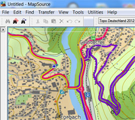 |
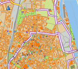
Mapsource does not support Active Routing but with some trickery you can make them visible.
Red lines are hiking trails, purple cycle routes.
|
Active Routing in OSM
|
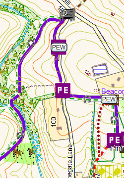
You do not need NT TOPO 2012 maps to create active routing - in fact, using mkgmap , you can do much more than highlighting a highway in different colours - you can add symbols of your hiking/cycling etc routes as shown in picture left.
The equivalent in OSM for active routing is the 'relation' tag.
|
 |