Best Calverleigh Walks | exploring rural Devon |
Calverleigh is a charming and peaceful village with a manor house called Calverleigh Court.
The name may refer to a meadow with steep hills (leigh) where calves graze.
| PDF of Walks in this area |
| Rose and Crown , Calverleigh but not en route | |
| Calverleigh Village Hall | |
| what3words ///arch.skill.finalists | |
|

Walk 1:Calverleigh to Loxbeare (4.2 miles)
Difficulty:![]()
| Calverleigh Village Hall |
| what3words ///arch.skill.finalists | |
| SATNAV Postcode:EX16 8BA |
An invigorating walk into a very secluded area of Devon.
The Walk
The landscape West of Tiverton is quite hilly so any walk in this area is bound to include steep hills.
A From the car park turn Right and head towards the main road.
Cross over diagonally Left into a quiet lane showing a signpost marked Lurley.
BJust past the letterbox on your left take track on your left.
Continue for just over a mile until you reach a lane and a few houses.
C Where the lane bends to the right take footpath on your left.
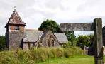
You can make a short diversion to Loxbeare by continuing along the lane and at the T junction with another lane turn Right to Loxbeare church. There used to be a school on left near the church.
The origin of the name implies a 'wooded area' (beare).
Retrace steps until you reach the footpath you recently bypassed .
D The next stretch is a steady climb.
Follow path with hedges on your left until you reach Leigh Barton Farm. Continue along drive which is also a public footpath.
Carefully cross Rackenford Road into a lane heading West.

After a steady 150 m climb, turn left onto a track (a public bridlepath) opposite some houses with a red telephone box and continue through a wooded area. There used to be a mill near the stream.
At T junction with another track turn Left, past Hill Farm (on left) and continue heading east
E Turn right at a lane then almost immediately left into Frogwell.
Follow the lane for 1/3 of a mile where it continues as a public bridleway.
This is quite a steep climb until you reach a lane called Tombstone Lane.
Turn left then soon take a bridle path on your left and descend until a junction near a small woodland.
FTake track left which after a while becomes a lane, leading you back to Calverleigh.
Download Route
| Download GPX | Mobile or GPS | |
| Download FIT | Watches |


Calverleigh Walk 1
| Walks near Calverleigh: | |
| South Molton | |
 | Discover the charm of South Molton on a scenic walk! Explore hidden trails, historic landmarks, and breathtaking countryside views in this picturesque North Devon town. |
| Rackenford | |
 | Enjoy a scenic walk through rural Devon, following part of the Two Moors Way and skirting Knowstone Moor. |
| Tiverton | |
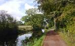 | Various options including a delightful canal walk - you may meet a shire horse pulling a barge! |
| Witheridge | |
 | Enjoy a rural walk following part of the Tarka Trail explores the hidden and more secluded woodlands and streams of Devon. |
Walk 2: Calverleigh to Loxbeare (6.5 miles)
Difficulty:![]()

| Calverleigh Village Hall |
A strenuous but rewarding walk to Loxbear and other hidden hamlets using quiet lanes , foot and bridle paths.
The route takes you to Loxbeare church, North& West Sidborough and Frogwell.
There are no pubs en route.
Download Route
| Download GPX | Mobile or GPS | |
| Download FIT | Watches |

Calverleigh Walk 2