
What is a GPX file?
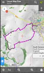
- A gpx file contains points on a route. These points are just coordinates displayed as dots on a line - see below
- The points can include elevation telling us the height above sea level so it can detect steep climbs or descents!
- When you switch on your gps you can see your position and lines representing the route.
If you can't see the route you need to zoom out. - You walk towards the nearest point on the 'route line' until you are on the route itself.
- Without a gps you often need to 'get your bearings',particularly if you have parked away from the suggested parking area!
Why bother with GPX files?
Anyone used to written instructions will find it hard to appreciate the value of a 'gps device' for walkers .
True, it's more fun to unravel text or regularly consult maps than follow an arrow on a device.
However, if you are tired of going wrong because of missing signs/clues or unclear instructions, a gpx file on a mobile or gps device tells you to take the correct turn at the right time ,useful particularly in forests and open fields or if the footpath runs through a farm!
Actual Written Instruction :
'Next, cross the field to a stile in small gap in hedge..
How many of us have followed hedges just to locate a stile?
- Install Locus Map Free or OSMAnd
- Download GPX .
- Your mobile should automatically select the appropriate app , ie Locus Map or OSMAnd.
- Import GPX (no need to unzip)
- Allow app to know your location
- You may have to send the gpx file to yourself then share it to the gpx app.
I have downloaded a gpx file - now what ?
Your gpx file contains the route of a walk. It has to be unzipped - on a PC
Why is is zipped in the first place?
Unfortunately , some browsers, when trying to read a gpx file if unzipped, open it as text , which is very confusing.
How to unzip?
Once downloaded, right click on the file and select Extract All
How do I know in which direction I need to walk?
The app you are using should tell you how long it would take to the destination point.
If you are following the route but the distance to the destination seems to get longer, you are walking in the opposite direction.
Can I reverse the route?
On most apps you can - just check out the various options.
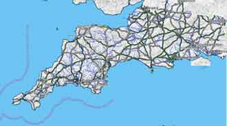
South West Hiking Map 2026
Includes Devon , Cornwall , Somerset , Avon
Dorset , Wiltshire & Hampshire
| Checkout Free Garmin Map of the South West |
Basecamp will show your gpx but it needs a map of the area. Download from here.
We have produced a free map of the South West which can be downloaded and installed on Windows. It clearly shows footpaths , bridleways and many long distance routes.
Check out Free MapOnce installed select your map named Topo Southwest .
(Garmin calls maps products)
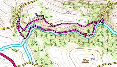
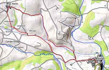
Route shown in Magenta on Basecamp
Install Google Earth (It's free!)
When double clicking on a KML file , your computer automatically opens it on Google Earth.
Search the net for Google Earth (FREE) ,then download and install.
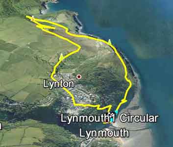
All our kml files show starting direction in Cyan - see map.
How to upload FIT files
Modern devices like watches prefer FIT files to GPX files.
Garmin devices :
1) Connect via USB to PC/Mac
2) Drop FIT file into \GARMIN\NEWFILES
3) Go Navigate,Courses and find your route ('course')
4) Some FIT files include directions and 'food' & 'water' stops.
How to view FIT files
Download our FIT ConVerter
What are the best satnavs for walking?
For more information and what to look for when buying a GPS