Branscombe Walks | high up following the Jurassic coast |
| Walk 1 (2.5 miles) | Walk 2 (3 miles) | |
| Most popular | Fountain Head |
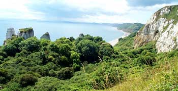
Enjoy spectacular views of the Jurassic Coastline following well maintained footpaths.
Branscombe is a typical Devon combe , a valley with green fertile pastures and steep uncultivated sides. In the past , being tucked away, it was well hidden from casual pirates.
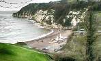
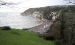
| Jurassic Coast Combe: a green valley with steep sides Branscombe was known for its lace. | |
| Masons Arms Fountain Head | |
| The Old Bakery | |
| Sea Chanty Beach Cafe | |
| Pay & Display Branscombe Mouth | |
| what3words ///domain.initial.zebra | |
| SATNAV Postcode: EX12 3DP |
Walk 1 Most popular (2.5 miles)
Difficulty:![]()
A delightful coastal and inland walk with spectacular sea cliff views.
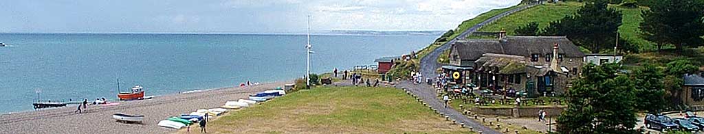
| Start :Branscombe Beach |
The Walk
A It starts from Branscombe beach near the Sea Chanty Beach Cafe with quite a strenuous climb ahead.
B Once at the top the views are stunning.
C Half way , turn right and follow a country lane with several thatched cottages; you pass Branscombe Church, one of the oldest churches in Devon.
D Continue past the Post Office.
E Site of Old bakery, Manor Mill & Forge.
F You may be tempted to deviate from the route to the Masons Arms ![]() in Branscombe.
in Branscombe.
Download Route
| Download GPX | Mobile or GPS | |
| Download FIT | Watches | |
| Google Earth | ||

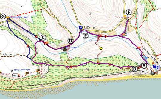
Walk 1 (red A to F)
| Walks near Branscombe | |
| Beer | |
 | This is a must do walk if you are in this area - it will involve some climbing but views of coastline are breathtaking. |
| Seaton | |
 | Two great walks from this popular holiday resort combining sea and countryside. |
| Donkey Sanctuary | |
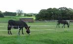 | A short but invigorating family walk from the Donkey Sanctuary to the Jurassic Coast where in 2007 the Napoli ran aground. |
| Salcombe Hill & Salcombe Regis | |
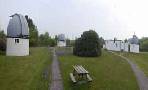 | Enjoy a picnic with spectacular views of the coast and explore the famous Norman Lockyer Observatory where helium was first discovered. |
Walk 2 Fountain Head (3 miles)
Difficulty:![]()
| Start :Branscombe Beach |
Similar to first walk but taking in the Fountain Head pub.
The Walk
A Starts and finishes as in walk 1.
G passes the Fountain Head pub ![]() around the half way mark. North of the pub, on top of the hill, lies Branscombe Airfield.
around the half way mark. North of the pub, on top of the hill, lies Branscombe Airfield.
length: | 3 miles |
terrain: | tracks bridle/ paths |
| lanes | |
main roads | 0 % |
altitude range | 0 - 120 m |
quality of track | *** |
Download Route
| Download GPX | Mobile or GPS | |
| Download FIT | Watches | |
| Google Earth | ||
There is one steep climb at the beginning.
Walk 2 ( A to G)