| Best Devon Walks |
| Best Devon Walks |
| Best New Bridge Walks |
| 4 TOP Walks |
| Walk 1 | Around New Bridge |
| 1.9 miles (50 mins) | |
| 3800+ steps | |
| Walk 2 | New Bridge to Holne & Wellsfoot Island |
| 2.9 miles (1h 20) | |
| 5800+ steps | |
| Walk 3 | New Bridge & Leigh Tor |
| 2.1 miles (1 hour) | |
| 4200+ steps | |
| Walk 4 | New Bridge to Ponsworthy |
| 6.4 miles (2h 40) | |
| 12800+ steps | |
| Nearby |
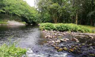
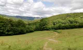
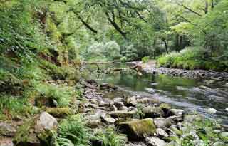
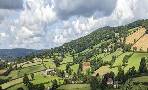
All walks from New Bridge follow wooded paths along the romantic river Dart.
The scenery is both breathtaking and magical !
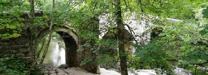
| River Dart | |
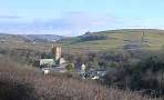
| The Church House Inn at Holne (see walk 2) | |
| Pay & Display New Bridge Car Park | |
| what3words ///revision.lectured.averages | |
|
| Please note :Car Park can be full during the weekend! |
| Walk 1 Around New Bridge (1.9 miles) |
![]() Difficulty:
Difficulty:![]()
An ideal walk for a picnic or a paddle in the river.
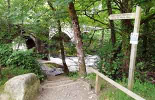
From the Car Park take footpath signed 'Deeper Marsh (Spitchwick) on right side of bridge.
Caution: steps are quite steep and surface near bridge uneven.
Pass under the bridge and follow a delightful footpath along the river through wooded areas and meadows.
When you have reached a lane return the way you came.
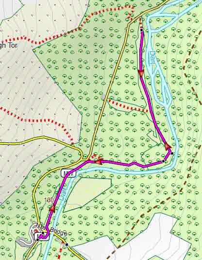
Map of Walk 1
Download Route
| Download GPX | Mobile or GPS | |
| Download FIT | Watches | |
| Google Earth | ||
| Walk 2 New Bridge to Holne & Wellsfoot Island (2.9 miles) |
![]() Difficulty:
Difficulty:![]()
A lovely pub walk following public footpaths and quiet lanes.
A From the main Car Park cross the bridge and turn right in to a footpath behind a small car park.
This stretch along the river is less popular but quite delightful and very peaceful.
B After 1/3 of a mile the path forks . Take the LEFT fork and climb steadily towards Holne.
Continue for half a mile following the Dartmoor Way & Two Moors Way until you reach a country lane.
C Turn left then soon take the next right.
Continue into Holne with ![]() pub ahead on your right. The Church House Inn is a friendly pub, now under new management, serving lunches and evening meals - it is highly recommended (July 2019) .
pub ahead on your right. The Church House Inn is a friendly pub, now under new management, serving lunches and evening meals - it is highly recommended (July 2019) .
During the weekend the ![]() Holne Community Shop & Tearoom is open at specific times.
Holne Community Shop & Tearoom is open at specific times.
Return they way you came and when you reach B turn left and follow the path along the river walking through a most beautiful woodland.
D At Wellsfoot Island the path climbs up again. Return the way you came, to the car park.

Map of Walk 2
Download Route
| Download GPX | Mobile or GPS | |
| Download FIT | Watches | |
| Google Earth | ||
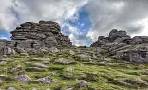
| Walk 3 New Bridge & Leigh Tor (2.1 miles) |
Difficulty:![]()
A great walk to Leigh Tor following mainly public footpaths.
The Walk
A Start as in walk 1 but when the river path meets the road , cross over.
B Continue on a footpath climbing steadily to Leigh Tor.
C Continue west to a car park then cross a lane and follow a footpath for about 100 m.
D Where it joins a country lane either turn left or cross over onto a grass path and turn left at the next junction then rejoin lane.
Follow quiet lane back to the main car park.

Map of Walk 3
Download Route
| Download GPX | Mobile or GPS | |
| Download FIT | Watches | |
| Google Earth | ||
| Walk 4 New Bridge to Ponsworthy (6.4 miles) |  | |
| MAP |
Difficulty:![]()
A strenuous but most rewarding walk to Ponsworthy via Spitchwick Manor & Doctor Blackall's Drive.
It returns via Ash Tor following the Dartmoor Way and part of the Doctor Blackall's Drive.
Doctor T Blackall of Exeter when he resided at Spitchwick Manor had a track built near Aish Tor so his invalid wife could be driven in a pony and trap across the moors and enjoy the spectacular views and dramatic scenery.
Download Route
| Download GPX | Mobile or GPS | |
| Download FIT | Watches | |
| Google Earth | ||
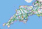
| FREE SOUTH WEST HIKING MAP |
|
| Walks near New Bridge | ||
 | ||
| Ashburton | ||
 | ||
| Buckfastleigh | ||
 | ||
| Haytor | ||
| (©) Pinns UK |