| Best Devon Walks |
| Best Devon Walks |
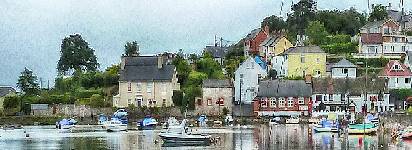
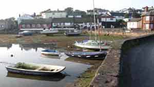
| Best Cockwood Walks |
| 2 TOP Walks |
| Walk 1 | Short Walk around Cockwood |
| 1.6 miles (40 mins) | |
| 3200+ steps | |
| Walk 2 | Starcross to Cockwood |
| 7.2 miles (3 hours) | |
| 14400+ steps | |
| Nearby |
| The Anchor Inn, The Ship Inn |
| Walk 1 Short Walk around Cockwood (1.6 miles) |
Difficulty:![]()
This is a very popular walk starting near Cockwood harbour involving one steady climb and descent with views of Haldon and the estuary.
The walk passes a wood on your left where , not so long ago, pigs were kept.
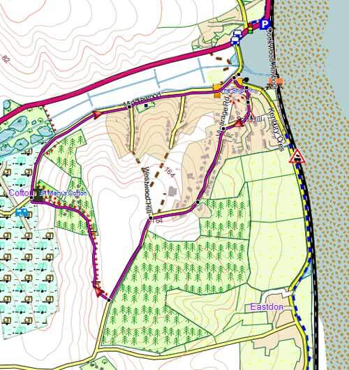
Map of Walk 1
Download Route
| Download GPX | Mobile or GPS | |
| Download FIT | Watches | |
| Google Earth | ||
| Small Parking Area off Dawlish to Starcross road, near railway line - see P on map. |
| Walk 2 Starcross to Cockwood (7.2 miles) |
Difficulty:![]()
It was always a popular place during the 19th century . 'Many persons resort to it who cannot bear the stronger sea air of the coast.It had it's name from a cross which formerly stood near the landing place on the estuary'. During the regetta 'balls and assemblies' were held in The Courtenay Arms.There used to be a 'pleasure-fair on White-Wednesday'.
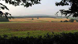
This scenic walk takes you along the Exe estuary, through Cockwood and towards Mamhead.
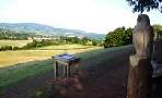
There are two pubs ![]() in Cockwood, the Anchor Inn,specialising in seafood and once a haven for seamen and smugglers, and the Ship Inn, equally pleasant.
in Cockwood, the Anchor Inn,specialising in seafood and once a haven for seamen and smugglers, and the Ship Inn, equally pleasant.
The Walk
AWith Brunel’s pumping station on your Left follow foot/cycle way on the right of the road to Dawlish, passing Golf Course on right.
At zebra crossing, cross over then turn left towards Cockwood.
Follow the road around the harbour towards the estuary passing The Anchor Inn on your right.
The road curves right then at a memorial place, turn Right into School Lane.
After the school ignore lane on left and bear Left where you join another lane (Vicarage Road).
BAfter half a mile climbing steadily , turn Right onto a public footpath (in the wood opposite pigs used to enjoy their freedom).
Continue along footpath with views of distant hills & campsite on left.
Once in the forest , follow public foot path descending towards campsite ignoring other tracks either side.
Continue with church on your right.
CWhen joining lane (Cofton Lane), turn Left and continue through campsite towards the main Dawlish Road.
At T junction, cross busy road into a lane.
Follow lane passing a garage workshop on left.
The lane becomes a track and continue following this track.
DWhere the track crosses another track take narrow track ahead of you descending towards a road.
At an old toll house , cross road into a lane (Butts Lane).
After 340 m , turn Right onto a track.
EAt end of track, turn Right onto lane.
At T junction , turn Right ; then almost immediately turn Left into Generals Lane.
After passing sports field on left , turn Left into carpark.
Follow path past Pavilions.
FAt end of path, turn Right and almost immediately Left into Waterloo Terrace.
At T junction , turn Right and continue back to car park / Starcross Station.
Map of Walk 2
Download Route
| Download GPX | Mobile or GPS | |
| Download FIT | Watches |
| Starcross Free Car Park | |
| Starcross Station |
There is one steep climb.
| Walks near Cockwood |
| Kenton |
 |
| See the estuary and the sea stretch in front of you while you walk towards Starcross. |
| Dawlish Countryside Park |
 |
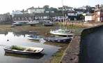
| A unique opportunity to enjoy Devon's native wildlife, flowers and grasses.The views of the coastline, Haldon, the Obelisk and Mamhead House are quite spectacular. |
| Dawlish |
 |
| Great walks from Dawlish, known for its sandy beaches, black swans & the Brunel railway line along its coast. |
| (©) Pinns UK |
