 |
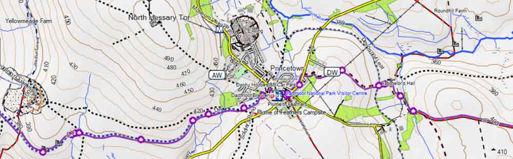
| Free Garmin Map of Southwest with footpaths & long distance hiking routes. |
 |
| FREE UK hiking maps for Garmin GPS devices & watches Includes Dartmoor and Exmoor,Lake & Peak Districts,Scotland & Wales |
What to Look for When Choosing a GPS Device for Walking or Hiking
Choosing the right GPS device can make a huge difference in your outdoor experience. Here’s a checklist of key features to consider:
🗺 Map Coverage & Route Planning
-
Does it show public footpaths, bridleways, and cycle routes?
Not all GPS devices include detailed walking maps by default — ensure yours does. - Can it find the quickest or most suitable route from A to B?
Some devices support smart routing depending on your mode of travel (walking, hiking, cycling). - Can it avoid busy roads or suggest scenic alternatives?
A good walking GPS should offer multiple routing options — safety and enjoyment matter!
🔍 Search & Navigation Features
- Can you easily search for addresses or points of interest?
Look for devices that let you find places like the nearest bus stop, station, pub, café, museum, or shop with ease. - Does it perform well in forests or remote areas?
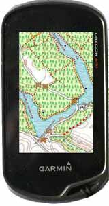
Devices with high-sensitivity receivers (like Garmin’s GPSMAP or Oregon series) are better at maintaining signal under dense canopy.
🌞 Screen Visibility & Usability
-
Is the screen readable in bright sunlight?
Some screens wash out completely in glare — look for models like the Oregon 600 with a bright color display. - Can you operate it with gloves on?
Button-operated models like the GPSMAP series are easier to use in cold or wet weather than touchscreen devices. - How big is the screen?
Smaller devices are compact but can be hard to read. Balance portability with clarity.
📍 Waypoints & Interface
-
Is it easy to mark a waypoint during your walk?
Some devices make this awkward — test how quickly you can save a location for later reference. - Are menus intuitive and quick to navigate?
Clunky interfaces can become frustrating over time, especially when you're tired or in poor weather.
🔋 Battery Life
Look for at least 10+ hours of continuous use.
Battery-saving modes can help extend this further on longer hikes.
💰 Map Costs & Compatibility
- Be cautious about map licensing!
Many devices tie maps to a specific unit, so if you upgrade or replace your GPS, you may need to buy your maps again — which we find quite unreasonable.
- Free maps are available — if your device supports them.
Garmin devices that accept .img files can load free OpenStreetMap (OSM) maps, which are regularly updated and surprisingly detailed.
📡 Signal Accuracy & Limitations
- All GPS devices struggle in certain environments:
Tall buildings, dense tree cover, even umbrellas can interfere with satellite signals, causing your position to appear ‘off-track.’ - Look for a ‘Lock on Road’ function
This feature can help correct inaccuracies when walking near roads or in built-up areas. (Note: car sat navs lock on roads by default.) - GPS does not work in tunnels — something to keep in mind for urban or mountain hikes.
How does it work?
- A GPS needs a map of the area you are walking.
Maps can come with the device ; more often they have to be bought separately. - If you have a Garmin you are able to take advantage of free Openstreetmap maps which, depending on the area, may or may not contain all footpaths.
- A GPS device generally does not include a selection of routes/tracks.
These you need to create yourself using software supplied with your maps. Alternatively, you can download routes; the most common are in a gpx format. - Some TOPO maps include a database of long distance hiking routes, ie TOPO Germany.
- Routes contain a set of instructions from one waypoint to another.
- Tracks are trails left behind by the walker - they are more detailed and can be more accurate.
- Routes are saved as a GPX (or FIT file for watches)
- All our walks include free GPX and FIT files
- You use the software to create routes and upload them to your device via a USB connection. Today,this is quite a straightforward process.
- You can use a GPS without routes/tracks but you will not have an ETA.
OS50 Maps
- Some GPS systems come with or can import OS50 maps.
- These might look a good option if you prefer OS50 maps - however,it is our experience that such maps are not as accurate as they should be , particularly , when following foot paths - you could be out by 30 feet.
- When you zoom in you get a blurry image.
- Again, footpaths change rapidly in response to local developments and may have been diverted or even removed !.
- We've developed a detailed OS-style map of the South West, tailored for walkers and cyclists, fully compatible with Garmin GPS devices.
Check out here.
Create your own maps
- There is another solution but its a bit 'techy'.
If you want to upload the latest maps for free and your gps supports 'img' import then we would recommend OpenStreetMap.
Such maps are created by volunteers - you could be one of them - and may not include all the public footpaths . Remember , they are free and can be very detailed! - Countries can be downloaded and uploaded to your gps.
- Try our most popular & free mapuploader 6.