
Tricks & Tips : multiple tags
Problems with multiple tags:boundaries
More Tricks
Today, many rivers,highways have an added 'boundary' tag. This saves space but can also lead to unexpected results.
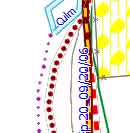 |
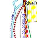 |
| boundary no river | boundary & river |
As I had all my boundary tags at the beginning of my lines file, I forgot to add 'continue'
boundary=administrative [0x1c resolution 24 continue]
Problems with multiple polygon tags:tourism
Again , be prepared for unexpected tagging. Loch Ness is tagged as natural=water AND tourism=attraction
I had both tags as solid polygons and tourism had a higher draworder in my TYP file.
In my case, I'm not too bothered about showing tourism polygons so added:
natural=water & tourism=attraction {delete tourism}
Next
How to create large town names
Showing contours in different intervals,50,100,150,200 etc