

MapUploader 6 LI Free for Windows 10/11 |
Tired of 3rd party Garmin maps? It's time to create your own !
Quickly select your options
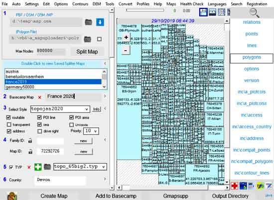 |
France has been downloaded from Geofabrik and split using splitter On right are listed all files in your current style. |
DEM & Contours
|
MapUploader 6 LI enables you to create maps of every country with DEM and contours . 1) Download the correct Java version (Java 64 not Java 32 for W10 64bit) 2) Go Tools,Fix Registry Problem to solve issues when uploading map to Basecamp,Mapsource |
 |
MapUploader 6/7 Full version
A full version of Mapuloader 6/7 is not available.
Style 2 TYP 2.1
- This new version creates a TYP file from ALL Elements found in Points,Line,Polygons and any files in a INC folder.
- Just Click Create TYP
- Tick if you wish the add mggmaps's tag as a label for each element
- Elements are rendered using Garmin's default colours & patterns
- Polygons can be rendered using a Mapnik style.
Resolution Plotter 2.71
Enabling smooth zooming in and out of maps
. |
With Mapuploader 6 unzip and add to plugs folder
|
Why maps can fail !
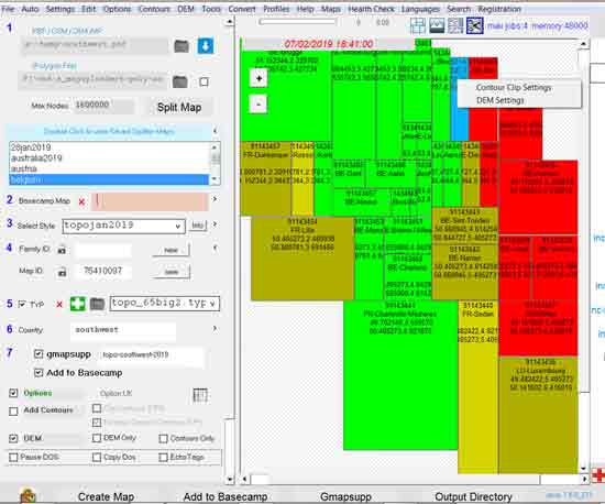
JVM memory
For larger maps and contours XPM 1024 is not sufficient.
However, some 32 bit PC's with 8 gig memory can not cope with xpm 2048 ! Trial an error is required ie perhaps 1100 .
On a 64bit W10 you MUST select java for 64bit else you will have memory issues
max-jobs
Not setting max-jobs can lead to problems.
Again, trial and error is needed. Try 4 then reduce number.
max nodes
With large maps reduce max nodes to 8 00 000.
Poly Editor
Important !
To avoid registry issues we recommend you install the test map:
go Tools,Fix Registry Problems and click OK when prompted.
This ensures future access to c:\garmin\maps where all maps are to be installed.
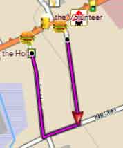
Routing problems with high speed roads
In Basecamp the 'hiking' option can produce curious results - see right. The shortest way seems to be the longest (A) ! If you add 'sidewalk' to your code you can 'force' it to join a primary Road by changing class and speed (B) . highway=primary & sidewalk!=* [0x3 road_class=3 road_speed=4 resolution 22] Use TYPWiz 7 to add sidewalks parallel to the highway. |
 |
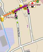 |
| A no sidewalk | B with sidewalk |
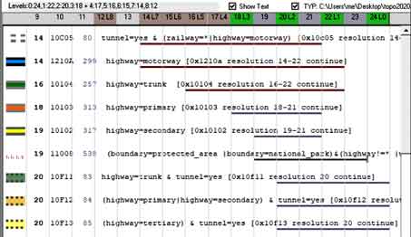
Contours
Contours are created in .osm format and can be processed in style sheets.
Depending on your settings contour files can become extremely large.
We propose clipping your contour files
1) Select Tile(s)
2) Select your target folder : Contours,Clip Settings
3) Clip : Contours,Clip contours for selected tiles (f8)
4) When creating a map tick 'Existing Clipped Contours'
Tips
In splitter option add
--geonames-file=bounds/cities15000.txt # tile gets appropriate city name
Download file and place in /bounds
In a mkgmap option add
--bounds=bounds\bounds.zip # download file and place in /bounds
--show-profiles=1 # adds elevation data to Basecamp when DEM has been selected
--latin1
What's NEW
| Checkout What's NEW |
Manuals
| Manual for MapUploader 6 PDF | |
| Using Clipped Contours | |
| Style Tricks 5 | |
| Quick Tutorials PDF> for creating maps with DEM and contours with MapUploader 6 |
Download Mapuploader LI
| » Mapuploader LI |
How to fix java,registry & memory problems
Click here for more information
More features , Tricks, DEM