
MapUploader 6 Extra Features
Automate
- Using a series of commands ( see here ) you can automate the process of
splitting,creating and launching your maps.
- Basecamp/Mapsource will always launch the map you have just created with detail level & profile preset by the user.
- download maps automatically - no need for web browser.
- 1 gig pbf map takes roughly 1 hour to both download and create
- A new map of Germany (3+ gig) with DEM & Contours took just over 3 hours to create using one click!
- All maps can be downloaded in same folder
- Easy to keep MAP ID the same so 'recent finds' on your GPS will work even when you update your map!
Checking Tiles for Contours or DEM files
 |
Quickly check which tiles lack the necessary HGT files or Contours! See our short Tutorial. |
How to create your own FREE Garmin Map in 4 Easy Steps
- Download openstreetmap data ( pbf) from Geofabrik
- Open file in MapUploader 6
- Tick DEM for Hill Shading
- Click Create Map
- (You need Basecamp , java & mkgmap , all free)
How to create your high definition own contours.
- Download hgt files - MapUploader 6 gives a list of required hgt files and download links.
Currently, most contours are created from 3'' STRM data. With Mapuploader6 you can use 1'' STRM data for most parts of the world.
- Set Interval 5 m - 1000m
- Click Create Contours - contours are created as osm files giving you greater flexibility.
- Tick 'Contours' to add the necessary contours
- Tick Clip to clip contours to the map area
YOUTUBE TUTORIALS
 |
 |
 |
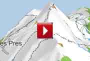
| How to create maps with Hill Shading (DEM) |
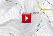
How to create & add high quality contours |
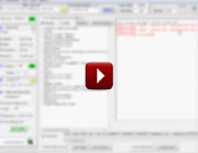
How to trap mkgmap style errors |
| Show Conflicting maps on your device | |
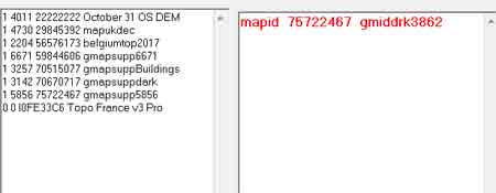 |
Go Tools, Collect Map IDs & FIDs |
| Highlighted in red are any maps which will be ignored by your device ! | |
| Convert KML or GPX files to IMG | |
GPX or KML (Google Earth) files can be converted into a Garmin compatible img file! From the Convert option on the main menu select 'Convert KML to MP' or 'GPX to MP' Once the files are converted to .mp they can be used by MapUploader. |
|
Check your TYP file
|
 |
Windows 10 and MapUploader 6
Mapuploader portable works on W10 but needs permissions only when adding maps to Basecamp/Mapsource: not when creating a map for your GPS device (gmapsupp.img)
1) Ensure Basecamp or Mapsource exist on your PC
2) Locate.reg file found in the folder which Mapuploader creates in a folder named after the your map, ie /mymap/mymap.reg.
3) Right Click on .reg file and run as administrator.
4) Check map target folder: c:\garmin\maps
5) Go Tools --> Create NSIS Window Installer and double click on the .exe when created
More Documentation
| Tricks with Styles | ||
| default.typ for mkgmap's default style | TIPS & TRICKs 4 | |
Initially , Mapuploader may be unable to write to the register when uploading maps to Basecamp or Mapsource. |
|
Use the following procedure - this needs to be done once only: 1) Set Map Target Directory to c:\garmin\maps 2) Download and install makensis.exe |
|
| 3) In Settings --> All Settings --> Key Software point to 'makensis.exe' on your harddrive. | 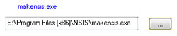 |
4) Create a map in mapuploader 5) Go Tools --> Create NSIS Window Installer |
|
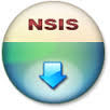
This may take a minute then click on 'Output Dir' and find the <name of map>.exe it has created - for icon see right. 6) Double Click to add map to register. |
 |
Can't Authenticate maps . Contact content seller for help
You may get message 'Can't Authenticate maps .Contact content seller for help' on
- GPS Maps 64 series
- Etrex 20x / 30x (not "etrex 30")
- Etrex Touch series
- Some new nuvi models
This happens if a gmapsupp has been created using the option --unicode.
It does not affect maps created using Mapuploader as long as you don't add the unicode option.
How to create a gmapsupp with Greek,Arabic,Russian etc characters and not use the -unicode option
This only applies to codepages 1250 - 1258 - see why
You can use a TYP file to show Greek,Arabic,Hebrew,Russian,Polish,Czech.
For the sake of convenience use codepage 65001 which incorporates all other codepages.
Abbreviating street names depending on their length
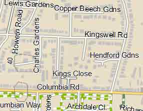 |
Road: Howeth Road Rd : Columbia Rd Close: Kings Close Cl. : Archdale Cl Gardens: Lewis Gardens Gdns: Hendford Gdns |
Latest Tip: 2c or not 2c ...
Garmin uses 0x2c12 for Castles,large buildings
However when you try plotting them at a resolution lower than 24 they only appear at resolution 24!
To ensure such buildings are searchable it is essential to use 0x2c12
Use another poi , say 0x12c12 also for castles
historic=castle|historic=fort [0x12c12 resolution 20-23 continue]
historic=castle {set name='${castle}'}[0x2c12 resolution 24]#feb2020
However, this didn't make any difference but the following works :
historic=castle|historic=fort [0x12c12 resolution 20-24 continue]
historic=castle {set name='${castle}'}[0x2c12 resolution 24]# transparent