Best Wembury Walks | enjoy magnificent coastline views |
| Select Your Walk | Walk 1 (3.4 miles) | (Pub) Walk 2 (5.9 miles) | |
| Warren Point | Heybrook Bay & Mussel Inn |
From Wembury Beach you get a good view of the dramatic Mew Stone , once inhabited by a few , now a nature reserve.
A church with its tower dating back to the 14th century acts as a land mark for mariners.
We've carefully planned two of the best walks from Wembury.
| The Great Mew Stone | |
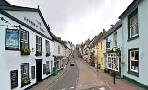
| The Mussel Inn in Down Tomas | |
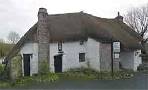
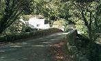
| The Old Mill, Wembury Beach | |
| Wembury Beach Car Park | |
| SATNAV Postcode:PL9 0HP |
Walk 1 Wembury to Warren Point (3.4 miles)
Difficulty:![]()
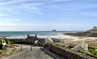
A coastal and inland walk with spectacular sea cliff views of the South Devon coast.
This popular walk follows the southwest coast path to Warren Point and returns using public footpaths and quiet lanes.
There is a cafe, The Old Mill, at Wembury Beach.
Expect spectacular views.
It includes a steady climb.
The Walk
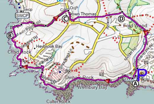
A Face the sea and turn left then follow southwest coast path with sea on your right.
B Continue for just over a mile until you join another foot path on your left.
C You have 3 options:
- Take this footpath on left and go inland.
- Continue following footpath along coast and descend to the river Yealm then turn left and take steps and return to C and walk inland.
- Continue ahead and descend and take steps to the river Yealm then turn right and return to C and walk inland.
D When reaching a lane continue for 160m then cross diagonally to your left and then follow public footpath keeping residential area on your right.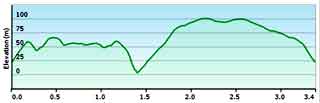
Download Route
| Download GPX | Mobile or GPS | |
| Download FIT | Watches | |
| Google Earth | ||

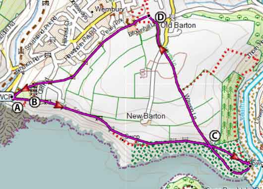
Map of Walk 1
| Walks near Wembury | |
| Noss Mayo | |
 | Two Best Walks with superb coastal views. |
| Yealmpton | |
 | Two great walks from a village that boasts Old Mother Hubbard's Cottage! |
| Loddiswell | |
 | Best walks through the Avon valley. |
| Modbury | |
 | Two great walks from Modbury, a historic market town known for its enchanting individual shops |
Walk 2 Wembury Point & Heybrook Bay (5.9 miles)
Difficulty:![]()
A delightful 6 mile pub hike along the cliff tops with fine views of Plymouth Sound.
The Walk
A Facing the sea turn right and follow coastal path with sea on your left.
B After skirting the old HMS Cambridge training school , cross the brook at Heybrook bay then continue following the coastal path for 1.2 miles until you join a lane.
C After 120 m take footpath on right and head inland . Continue in easterly direction along Manor Bourne Rd into the village of Down Thomas.
Turn right and soon you will see The Mussel Inn on your left.
Continue south and take flirts public footpath on your left and after 70 m (1 minute) take footpath on left and head east descending gradually to a brook.
D Cross brook and turn right with brook on your right. When you join another footpath turn right and at lane turn left and soon right onto another footpath and continue back to car park.

Download Route
| Download GPX | Mobile or GPS | |
| Download FIT | Watches | |
| Google Earth | ||
Map of Walk 2
 |
| FREE SOUTH WEST HIKING MAP |
|