FIT ConVerter What's New
Return to Main Page
4.60
- Support for decimal commas when creating GPX/TCX files
- Support for decimal commas when plotting graphs
- Rewrite of code to fix issues when saving preferences
4.51
- Support for TCX files with heart bpm data.
- Fit files created from any TCX file containing a particular 'Activity' are converted as an activity..
- In a TCX file some support for blocks of heart rate data not tied to a specific latitude & longitude.
- User can rename FIT files created from TCX.
- Various minor improvements .
4.43
- Fixed issue when converting certain gpx files to FIT
4.41
- Added Laps to Openstreetmap
- Added Popups showing relevant data
- Fixed Exporting Lap data
- Fixed some FIT files skipping laps
- Support for more detailed LAP info if available, ie enhanced speed.
- Print out Lap data (CTRL L)
4.36
- Fixed User Data not showing
- Added 'report a bug or make a suggestion' in HELP
- Show FIT route on Openstreetmap - Tick 'Openstreet'
Version 4.26
- Fixed issue when plotting field data in developer's mode
- Added compressed_time.fit as an example of a data stream
- SupportrBlack Background in Charts - see Preference
Version 4.22
Support for Compressed Timestamps and data streams
Show data streams in Raw Data - see FIT for Dummies
various bug fixes
Version 4.04
- Various bug fixes
- Many Improvements for Developer's Mode
Version 4.02
Show Google Map icon if google has been selected to display FIT file.
Version 4.01
- Increase speed and heart intervals to 5 .
- Allow multiple of copies of FIT Converter
- Speed improvement
- Fixed matching graph data to route when data was available but GPX hadn't kicked in
- Show , when available,VO2max ,Aerobic,Anaerobic values,Resthours etc
- For developers, show data for all message IDs graphically. Check out Msg ID 233, 160, 325 etc.
- Display undocumented data graphically
- Display Battery Percentages , GPS data, Recovery, Workouts etc
- Export Data based on selection of Field
- Various bug fixes
Version 3.70
- Added option to combine heart/speed data with altitude etc
- In Preference click 'Show One Element in Graph" to undo option
- Customise colours . Click on Colour in Preference to edit colour
- Correctly saves presence of java on PC
- Add option to show all data, labels and values, contained in a FIT file
- Add option to highlight all unknown global messages and fields and their values.
This makes it easier to identify some of the undocumented fields - Updated Latest Garmin Models
- Updated information regarding certain unknown fields and global messages
Version 3.67
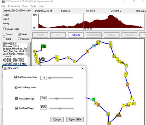
- Added New Course option : Course, New Course
- Fixed issue when 2 versions of the application are running simultaneously
- Various cosmetic improvements
- Added information for various definition fields not included previously
Version 3.65
- Add TBT directions to any FIT file which contains a route
- Include Swedish language
- Added Monitoring information
- Various improvements
Version 3.61
- Various improvements
- Checking for updates now under the Help menu
- Added 3 languages
Version 3.542
- Added support for showing TBT on a map
- Various minor bugs
- Check for java only when required
Version 3.531
- Fixed deletion of course points
- Right Click on Course Point for more options
- Added use of del key to delete course points
- Various minor bugs fixed
- CTRL S to save edited course
version 3.522
- Many aesthetic changes
- Fixed issues when auto calculating course points
- Raised minimum distance between course points to 500m
- Fixed issue of disappearing map when creating FIT from a GPX file.
- When selecting FIT folder , folder points to previous path
version 3.17
- Additional support for tweaking Turn by Turn directions :
- specify minimum distance in meters for including a course point .
- GPS devices can't cope with course points being too close to each other.
- Fixed half way points etc not showing
version 3.10
|
 |
| GPX to FIT |
Other Versions
version 2.1
|
 |
| Export |
version 1.61
- Various small bugs fixed
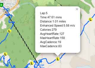
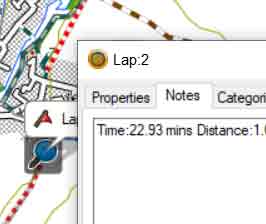
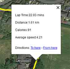
- Added support for showing LAPs as waypoint in a GPX / KML file
- LAP data includes Lap Time, Lap Distance,Calories, Average speed
- Go Settings and tick Add Lap Waypoints to GPX / KML
- In Basecamp Lap descriptions are show in 'Notes'
- Basecamp does not allow waypoints to have the same number ; Lap2 might be shows as Lap21 etc
- In Google Earth LAP descriptions appear when clicking on yellow lap markers
- On many devices you can mark a specific spot and identify its location by triggering the start of a new lap .
 |
| Waypoint Showing LAP Details |
 |
| Marker Showing LAP Details |
version 1.51
- Added support for complex headers
- Incorporated latest Garmin models
version 1.42
- Includes list of latest Garmin devices linked to a FIT file - if your device is not listed contact us
- New Look & Speed improvements
- Show graded Climbs and Descents where available
- Click and drag on Charts to match data to path
- Click on Lap icon to view Lap Data
- Press ESC to prevent very large FIT files from hanging up
- Display or Show Resets ('R') in Settings - R's tell you where you paused or resumed an Activity
- CTRL G gives you Google Maps
Version 1.31
Support Courses when saving tcx files
Show Course points in a FIT file when available - Click on point to show instruction:, ie Turn Left etc
Right Click on Laps to see Lap Data
Show Fit Route in Google Earth
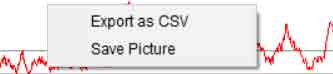
To save as CSV using FITCSVTool
download ANT's FitCSVTool.jar and place it in Fit ConVerter's /FIT sub folder
ensure you have installed java
Select fit file and go File,Save as 'CSV using FitCSVTool'