
FIT ConVerter What's New
Return to Main Page
4.60
- Support for decimal commas when creating GPX/TCX files
- Support for decimal commas when plotting graphs
- Rewrite of code to fix issues when saving preferences
4.51
- Support for TCX files with heart bpm data.
- Fit files created from any TCX file containing a particular 'Activity' are converted as an activity..
- In a TCX file some support for blocks of heart rate data not tied to a specific latitude & longitude.
- User can rename FIT files created from TCX.
- Various minor improvements .
4.43
- Fixed issue when converting certain gpx files to FIT
4.41
- Added Laps to Openstreetmap
- Added Popups showing relevant data
- Fixed Exporting Lap data
- Fixed some FIT files skipping laps
- Support for more detailed LAP info if available, ie enhanced speed.
- Print out Lap data (CTRL L)
4.36
- Fixed User Data not showing
- Added 'report a bug or make a suggestion' in HELP
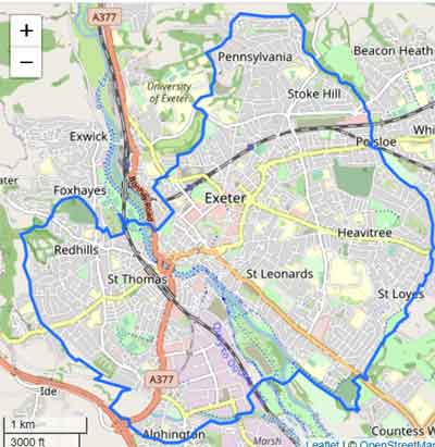
- Show FIT route on Openstreetmap - Tick 'Openstreet'
Version 4.26
- Fixed issue when plotting field data in developer's mode
- Added compressed_time.fit as an example of a data stream
- SupportrBlack Background in Charts - see Preference
Version 4.22
- Support for Compressed Timestamps and data streams
- Show data streams in Raw Data - see FIT for Dummies
- various bug fixes
Version 4.04
- Various bug fixes
- Many Improvements for Developer's Mode
Version 4.02
Show Google Map icon if google has been selected to display FIT file.
Version 4.01
- Increase speed and heart intervals to 5 .
- Allow multiple of copies of FIT Converter
- Speed improvement
- Fixed matching graph data to route when data was available but GPX hadn't kicked in
- Show , when available,VO2max ,Aerobic,Anaerobic values,Resthours etc
- For developers, show data for all message IDs graphically. Check out Msg ID 233, 160, 325 etc.
- Display undocumented data graphically
- Display Battery Percentages , GPS data, Recovery, Workouts etc
- Export Data based on selection of Field
- Various bug fixes
Version 3.70
- Added option to combine heart/speed data with altitude etc
- In Preference click 'Show One Element in Graph" to undo option
- Customise colours . Click on Colour in Preference to edit colour
- Correctly saves presence of java on PC
- Add option to show all data, labels and values, contained in a FIT file
- Add option to highlight all unknown global messages and fields and their values.
This makes it easier to identify some of the undocumented fields - Updated Latest Garmin Models
- Updated information regarding certain unknown fields and global messages
Version 3.67
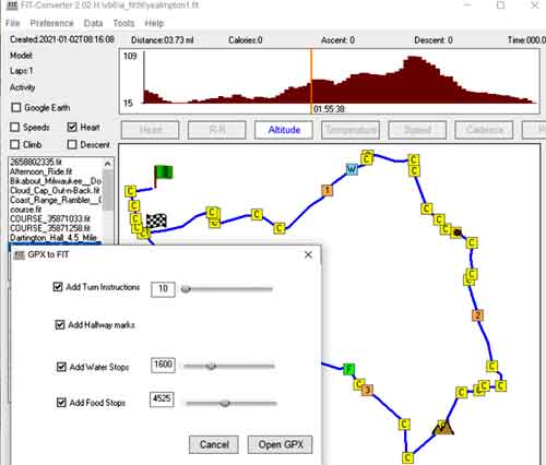
- Added New Course option : Course, New Course
- Fixed issue when 2 versions of the application are running simultaneously
- Various cosmetic improvements
- Added information for various definition fields not included previously
Version 3.65
- Add TBT directions to any FIT file which contains a route
- Include Swedish language
- Added Monitoring information
- Various improvements
Version 3.61
- Various improvements
- Checking for updates now under the Help menu
- Added 3 languages
Version 3.542
- Added support for showing TBT on a map
- Various minor bugs
- Check for java only when required
Version 3.531
- Fixed deletion of course points
- Right Click on Course Point for more options
- Added use of del key to delete course points
- Various minor bugs fixed
- CTRL S to save edited course
version 3.522
- Many aesthetic changes
- Fixed issues when auto calculating course points
- Raised minimum distance between course points to 500m
- Fixed issue of disappearing map when creating FIT from a GPX file.
- When selecting FIT folder , folder points to previous path
version 3.17
- Additional support for tweaking Turn by Turn directions :
- specify minimum distance in meters for including a course point .
- GPS devices can't cope with course points being too close to each other.
- Fixed half way points etc not showing
version 3.10
|
 |
Other Versions
version 2.1
|
 |
version 1.61
- Various small bugs fixed
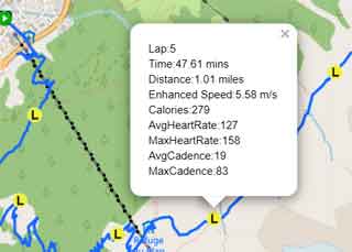
- Added support for showing LAPs as waypoint in a GPX / KML file
- LAP data includes Lap Time, Lap Distance,Calories, Average speed
- Go Settings and tick Add Lap Waypoints to GPX / KML
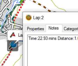
- In Basecamp Lap descriptions are show in 'Notes'
- Basecamp does not allow waypoints to have the same number ; Lap2 might be shows as Lap21 etc
- In Google Earth LAP descriptions appear when clicking on yellow lap markers
- On many devices you can mark a specific spot and identify its location by triggering the start of a new lap .
 |
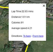 |
| Added support for showing LAPs as waypoint in a GPX file | Added support for showing LAPs as markers in a KML file |
| Click on Waypoint and click Notes Tab | Click on Yellow Marker to reveal Lap Data |
version 1.51
- Added support for complex headers
- Incorporated latest Garmin models
version 1.42
- Includes list of latest Garmin devices linked to a FIT file - if your device is not listed contact us
- New Look & Speed improvements
- Show graded Climbs and Descents where available
- Click and drag on Charts to match data to path
- Click on Lap icon to view Lap Data
- Press ESC to prevent very large FIT files from hanging up
- Display or Show Resets ('R') in Settings - R's tell you where you paused or resumed an Activity
- CTRL G gives you Google Maps
Version 1.31
- Support Courses when saving tcx files
- Show Course points in a FIT file when available - Click on point to show instruction:, ie Turn Left etc
- Right Click on Laps to see Lap Data
- Show Fit Route in Google Earth
- To save as CSV using FITCSVTool
- download ANT's FitCSVTool.jar and place it in Fit ConVerter's /FIT sub folder
- ensure you have installed java
- Select fit file and go File,Save as 'CSV using FitCSVTool'