| Best Padstow Walks | ||
| 2 Popular Walks | ||
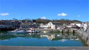 Padstow Harbour Padstow Harbour | |
| Walk 1 | Canal & coastline |
| 2.8 miles (1h 10) | |
| Walk 2 | Stepper Point |
| 7.4 miles (3 hours) | |
The area around Padstow enjoys some of the most beautiful bays & beaches,making this still a thriving fishing harbour an ideal center for walking.
On the 1st of May a 'obby 'oss can be seen prancing through the town ,celebrating the coming of summer.
The 'stow' means a place for assembly
| Harbour Prideaux Place Deer Park river Camel |
|
| Coastline | |
| Numerous Pubs in Padstow | |
| 1) P&R near Tesco 2) Main car Park |
| Walk 1 Canal & coastline (2.8 miles) |
 |
|
| MAP |
This easy walk starts at the harbour and passes an old church ,named after St Petrock founder of Padstow,and Prideaux Place ,an Elizabethan Manor overlooking an ancient deer park.
It returns via Harbour Cove along the edge of the river Camel with extensive views of the village of Rock where prince William and Harry used to stay.
| Difficulty |
length: | 2.8 miles |
time: | 1 hr 20 mins |
Download route for Mobile / GPS
| Walk 2 Stepper Point (7.4 miles) |  |
|
| MAP |
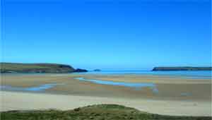
River Camel & Harbour Cove
| Difficulty |
This very popular and fairly easy walk follows the South West Coast Path to Stepper Point,near the mouth of the Camel,then continues along the coast towards Trevone and returns via Crugmeer passing Prideaux Place and its deer park.
download route for GPS / Mobile
download route for Watch / Mobile
| 1) P&R near Tesco 2) Main car Park |