Kentisbeare
Four very pleasant walks from this charming village.
Walk 1
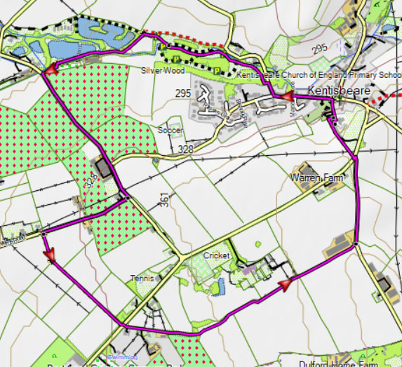
| Walk 1 Silver Woods (2.6 miles) | Time:1h 10 mins |
 |  Tap map for larger version | ||
| 3 old yews in church yard , Blackdown Hills | |||
| Kentisbeare Car Park behind church | |||
Shorter walk (55 minutes) takes you through Silver Woods, a conservation area, & along Goodiford Mill Fishery passing numerous small lakes full of wild life. It returns via quiet lanes, some flanked by orchards, and well maintained footpaths. | |||
| Show on Google Earth | |||
| GPX for GPS | |||
| How to view a GPX file |
| Walks near Kentisbeare: | |
| Broadhembury | |
.jpg) | An exhilarating walk from one of the most picturesque villages in Devon. |
| Dunkeswell | |
.jpg) | Three popular walks including a rewarding but somewhat strenuous ramble to the ruins of an old abbey |
| Cullompton | |
.jpg) | A great selection of river & country walks |
Walk 2
| Walk 2 Blackdown Hills (5.8 miles) | Time:2h 20 mins |
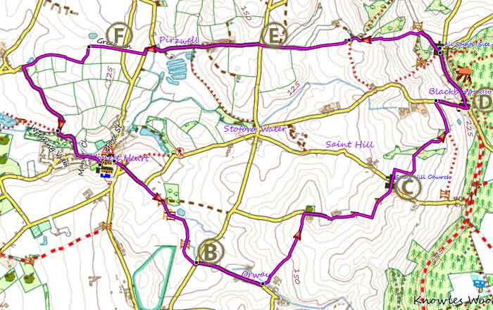 Tap map for larger version | The second takes you on to the beautiful Blackdown Hills from where you can see the Exe estuary.On the way back the footpath takes you past Blackborough House, a derelict manor house These directions are not to be used without a map: A From the car park walk towards the church and take a footpath to the right of the building. At the T junction turn right onto Priest Hill. After 130 where the road bends to the right take the left fork and continue along the lane until you see a track on right. Turn into the track and after a short while take footpath on right. Follow this path for 0.4 miles Turn left onto a lane then take lane on right. B Continue on this lane for 0.35 miles then after the farm yard turn left onto a Footpath. Follow this Footpath and after 0.41 miles turn right onto a service road. Continue in easterly direction.The drive turns into a track then into a path. | ||
| Take this footpath which eventually leads to Saint Hill. Where the track joins the lane continue left then soon take a footpath on right past the chapel.C Follow this path ( a steady climb) until you reach a lane - just before the lane the path runs parallel to a private drive. Turn right, still climbing, and turn left at the next junction, after a telephone booth. D .Continue along this lane through Blackborough (no pub) and past the cemetery on right. Just before a gate where the lane becomes a drive, turn left onto public footpath. Descend until you reach the beginning of a lane near some houses. During the winter this can be muddy. E After 0.2 miles you arrive at a junction. Cross over and follow the lane past Pirzwell farm. Ignoring a lane junction on right the road bends sharp left and soon you will see a track on right. F Follow this track (Green Lane) .After 0.69 miles turn left onto a lane called Silver Street .Follow this lane back into Kentisbeare. | |||
| see main parking area | |||
| GPX for GPS | |||
| Show on Google Earth | |||
| Download PDF | |||
Walk 3
| Walk 3 (6.4 miles or 7.1 miles) | Time:2h 40 mins |
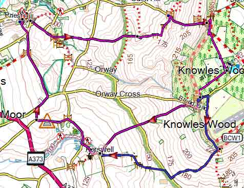 Tap map for larger version | This walk takes you to the Blackdown Hills,through a beautiful coniferous forest returning via Kerswell & Kerswell Priory. A 30 min longer version (blue) skirts the Devon & Somerset Gliding Club & descends using footpaths, tracks & lanes into Kerswell. There is no pub in Kerswell. | ||
| There is one pub | |||
| see main parking area | |||
| GPX for GPS | |||
| Show on Google Earth | |||
Walk 4
| Walk 4 (5.4 miles) | Time:2h 20 mins |
| see main parking area | |||